
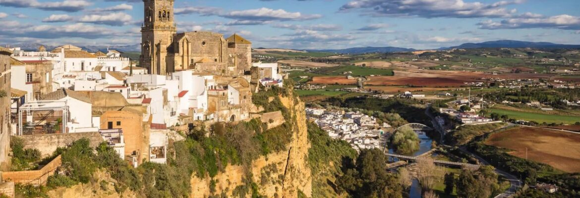
Located in the northwest of the province of Cadiz, Arcos marks the natural access to the Sierra de Grazalema and the classic route of the White Villages. Bathed by the river Guadalete, and next to the Arcos reservoir, it belongs to the region of the same name, of which it is the head of the district. It is well connected by road to Jerez de la Frontera and the Bay of Cadiz.
Its climate is characterised by very mild temperatures for most of the year. The mountain breeze moderates the high temperatures that are common in the province of Cádiz during the summer months.
The high crag on which Arcos sits has been inhabited since ancient times, as evidenced by the finds of Palaeolithic axes and the numerous Roman and Arab remains found in the area around the town.
The legend of the town’s origin has been passed down to its coat of arms, which reads that Arcobrigan was founded by King Brigo, the grandson of Noah. Finally conquered from the Arabs in 1264 by Alfonso X the Wise, it became part of the chain of fortresses established as a Christian parapet against the Muslim razzias, adopting its second name “de la Frontera".
After an initial stately period, Arcos became the main centre of the possessions of Rodrigo Ponce de León, Marquis of Cádiz and first Duke of Arcos (1493). The town remained linked to this noble family until well into the 18th century.
Its status as a stately capital and the consequent cultural patronage exercised by the powerful Dukes of Arcos have allowed the city to treasure important artistic gems from all periods. In Arcos there is the exceptional circumstance that the Christian city preserves the pre-existing urban structure, without the usual demolitions and enlargements carried out in other towns.
Nowadays, in addition to the traditional agricultural and livestock farming, there has been an important development of tourism, with the precedent of being declared a Historic and Artistic Monumental Site in 1962.
Arcos de la Frontera1 is a Spanish municipality in the province of Cádiz, Andalusia. It is the most populated municipality in the Sierra de Cádiz region and also the largest. It is an important place for inland tourism and regional industry, and has a strategic position between the Jerez countryside and the Serranía. It also has a rich past, having been the capital of the Taifa of Arcos in the Muslim period and capital of the Duchy of Arcos from 1493.

History
Like most of the towns in this province, its location has been occupied by human beings since prehistoric times. Arcos, due to its geographical location, has always been a strategic place. The name Arx-Arcis (fortress in height) comes from its Roman foundation, a period in which it appears as a settlement “coloniae Arcensium", another Roman settlement was Santiscal.
During the Muslim period it was called Arkos, emerging as a truly prosperous and flourishing city. During the period of the Emirate dependent on Damascus (711-757) it belonged to the “Cora" of Sidonia. In the 11th century, it became a small Taifa kingdom under the rule of Ben Jazrum, a king of Berber origin. During this period, the town was walled in and although it is not certain that all the land was filled with buildings, the complex grid of blocks has been maintained. The layout of the streets, the military fortress, the wall, the mills, etc. date from this period.
In 1255 and 1264, King Alfonso X took the city for Castile, being ceded to the Infante Don Enrique, although it returned to royal hands due to its frontier character. In 1300 it received the rank[citation needed] of council.
In 1408 the king placed the town in the hands of his private owner Ruy López Dávalos, to be granted to the Ponce de León family in 1440, Dukes of Arcos, until well into the 18th century, reaching its zenith between the 15th and 17th centuries. In the 15th century the Hospices de los Franciscanos Descalzos (Hospices of the Barefoot Franciscans) were founded, as well as another next to the Church of San Pedro. The Town Hall was moved to the Plaza del Castillo. The prison was moved to a house where the Convent of the Discalced Mercedarias Descalzas was later built. In the Plaza del Castillo the alhóndiga was located and behind it the slaughterhouse.
From the 16th century onwards, construction began on the Convent of San Francisco (1510), that of the nuns of San Juan de Letrán (1539), the Hospital of San Roque and that of San Pedro. Construction also began on a new slaughterhouse outside the Puerta de Jerez. During the 18th century there was an urban expansion that exceeded the extension of its Arab walls.
In 1706, Philip V granted it the title of Noble and Most Faithful. The Lisbon earthquake of 1755 changed its appearance, affecting the churches of Santa María, San Pedro and San Agustín, and the north wall of the castle collapsed, falling into the moat and burying it, giving rise to the Calle Nueva.
During the 18th century, the city developed definitively outside the walled enclosure, giving rise to three enclaves: the Corredera neighbourhood, the most upmarket, with the residences of the bourgeoisie, Hospital de San Juan de Dios, Pósito de Carlos III, Mesón del Duque and Church of San Miguel; the San Francisco neighbourhood, around the 16th century Church of the Franciscans, in which the Capilla de las Aguas stands out; and the Bajo neighbourhood, whose origin may lie in a Moorish settlement in the current neighbourhood of Competa.
In the 19th century, apart from the yellow fever epidemic and the passage of the French, which caused damage to the Castle and the Plaza, the most important event for the heritage of Arcos was the disentailment of Mendizábal. Religious buildings were transformed and rural ecclesiastical possessions were put up for sale, which slowed down the incipient industrial development, due to the transformation of the industrial promoters into landowners.
In the 20th century, the quality of life improved and the tourist sector developed, with the period 1950-70 seeing the greatest growth of the city. Until the beginning of the 1960s, a concentric ring of growth was formed. But it was from this decade onwards when new building typologies began to appear (blocks and detached, semi-detached and row houses) built on new layouts, which threatened both the original walled urban centre and the first growth area and the traditional farmhouse. In the 21st century it has become the entrance to the Route of the White Villages and a Historic-Artistic Site. Together with its magnificent scenery, it is a major tourist destination in the province of Cádiz, which is its main source of income
Geography
In 2008 it had 31,017 inhabitants. Its surface area is 528 km² and it has a population density of 55.7 inhabitants/km². Its geographical coordinates are 36º 45′ N, 5º 48′ W. It is located at an altitude of 185 metres and 67 kilometres from the provincial capital, Cádiz. It is located on a hill next to the river Guadalete.
It is bordered to the north by the municipalities of Espera (Cádiz) and Bornos, to the northeast by the municipality of Villamartín, to the east by the municipalities of El Bosque and Prado del Rey, to the southeast by the municipalities of Benaocaz and Ubrique, to the south by the municipalities of Algar and San José del Valle and to the west by the municipality of Jerez de la Frontera.

Properties in Arcos de la Frontera

Ref. 054 Apartamento turístico en Arcos de la frontera
- 1
- 1
- 50 m²
